Trail Walking Auronzo di Cadore - Tre Cime - Photo
© OpenStreetMap contributors
Length
Length
13.6 km
Max alt
Max alt
2523 m
Uphill gradient
Uphill gradient
756 m
Km-Effort
Km-Effort  
24 km
Min alt
Min alt
2168 m
Downhill gradient
Downhill gradient
758 m
Boucle
Boucle
Yes
Creation date :
2023-09-15 06:58:50.859
Updated on :
2023-10-02 15:21:11.057

(0 Reviews)

Walking
Walking
5h22
Difficulty : Very difficult

Scan this QR Code to open this trail in the SityTrail application

FREE GPS app for hiking

Logo SityTrail SityTrail

IGN / Geographical institutes

Download SityTrail from the App Store Download SityTrail from Google Play

Logo SityTrail SityTrail World

The world is yours!

Download SityTrail from the App Store Download SityTrail from Google Play Download SityTrail on Huawei AppGallery

About

Trail Walking of 13.6 km to be discovered at Veneto, Belluno, Auronzo di Cadore. This trail is proposed by GuyVachet.

Description

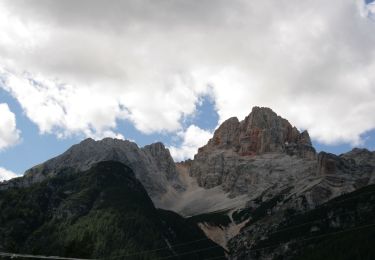
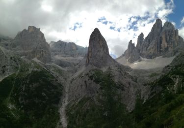
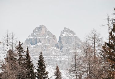
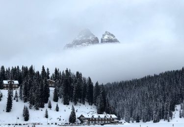
Ces 3 sommets sont emblématiques des Dolomites d'Ampezzo. La rando proposée permet de les découvrir en sortant du sentier battu (et rebattu). Départ à partir du refuge Auronzo (vous ne devrez pas être les seuls ;-). Mais pour échapper au moins pour un temps à la procession, cette boucle contourne le Mont Paterne et termine par une traversée au-dessus des lacs Piani avant d'arriver au refuge Locatelli. A partir de là, vous débouchez sur la face nord des Tre Cime, le « spot » des Dolomites.

Elevation profile

Photos

Positioning

Country:
Italy
Region :
Veneto
Department/Province :
Belluno
Municipality :
Auronzo di Cadore
Location:
Unknown
Start:(UTM)
292883 ; 5165534 (33T) N.

Trails nearby

Trail On foot Toblach - Dobbiaco - IT-34 - Photo
On foot
PRO

On foot

Easy
Toblach - Dobbiaco, Trentino-Alto Adige/Südtirol, South Tyrol, Italy
7.4 km | 16.5 km-effort
3h 44min
No
Trail On foot Toblach - Dobbiaco - IT-6A - Photo
On foot
PRO

On foot

Easy
Toblach - Dobbiaco, Trentino-Alto Adige/Südtirol, South Tyrol, Italy
4.2 km | 7.2 km-effort
1h 38min
No
Trail On foot Auronzo di Cadore - IT-107 - Photo
On foot
PRO

On foot

Easy
Auronzo di Cadore, Veneto, Belluno, Italy
5.9 km | 11.8 km-effort
2h 41min
No
Trail On foot Auronzo di Cadore - IT-120B - Photo
On foot
PRO

On foot

Easy
Auronzo di Cadore, Veneto, Belluno, Italy
3.8 km | 5.7 km-effort
1h 17min
No
Trail On foot Auronzo di Cadore - IT-120A - Photo
On foot
PRO

On foot

Easy
Auronzo di Cadore, Veneto, Belluno, Italy
3.8 km | 7.1 km-effort
1h 36min
No
Trail On foot Auronzo di Cadore - IT-224 - Photo
On foot
PRO

On foot

Easy
Auronzo di Cadore, Veneto, Belluno, Italy
3.3 km | 7.5 km-effort
1h 42min
No
Trail On foot Auronzo di Cadore - IT-121 - Photo
On foot
PRO

On foot

Easy
Auronzo di Cadore, Veneto, Belluno, Italy
8.1 km | 17.1 km-effort
3h 53min
No
Trail On foot Auronzo di Cadore - IT-1104 - Photo
On foot
PRO

On foot

Easy
Auronzo di Cadore, Veneto, Belluno, Italy
5.2 km | 14.7 km-effort
3h 19min
No
Trail On foot Auronzo di Cadore - Misurina Casello - Rifugio Auronzo - Photo
On foot
PRO

On foot

Easy
Auronzo di Cadore, Veneto, Belluno, Italy
3.3 km | 7.8 km-effort
1h 46min
No


Close
My subscriptions